
Menu:
How much does the 'Sunset Experience Trip' cost and when is it paid?
-The price for a 'Sunset Trip' is 55€ or equivalent in egp.
(there is a discount for children <10y, residents and Egyptians).
Payment is made upon departure to the desert.
-Prices 'Special Trips' on request.
Where and how is the start of the 'Sunset Experience Trip'?
-The meeting point is at the 'Sharqi/Caleo restaurant' and the 'Karibu bar & restaurant'.
(El Gouna downtown, opposite Go Bus office).
-We start from there with safari jeep(s) in the direction of the desert/ Wadi Bileh.
From what time to what time does the 'Sunset Experience Trip' last?
-Normally we gather around 2pm and we are back in El Gouna at 8.30pm
(during the winter months).
-During the summer months we leave at a later time (4pm) because of the late sunset.
What should we bring for ourselves to the trip?
-Certainly a small bottle of drinking water. Easy walking shoes or light hiking boots. Wear comfortable clothes and for the rest something warm to put on after sunset during the winter months. (Extra refills drinking water is provided by us).
Are the mountain goats only intended for people who are in El Gouna?
-Everyone is welcome with us. Gounies as well as people from outside El Gouna,
Egyptians and non-Egyptians.
What about taking photos?
-During a trip, photos may be taken by the mountain goats team as well as by other hikers. Participants consent to the use of their images for promotional purposes and publication on social media, unless otherwise specified by them.
Cancellation policy:
Some background information about our 'Trips':
-Most of our 'Trips' take place in Wadi Bileh and the surrounding area. Wadi Bileh, once a river that carved its way through a fossilized seabed is now a dry valley or ravine. In case of exceptionally heavy rainfall, it can happen that its becomes a water course. It takes its name from an old Arab tribe, the Bileh, who arrived in Egypt from Saudi Arabia after the Islamic Conquest.
Prior to the Muslim conquest of Egypt, Egypt was under Greek and Roman influence.
After the conquest Arabic became the official language in Egypt rather than Coptic or Greek.The caliphate also allowed the migration of Arab tribes to Egypt.The Muslim governor of Egypt encouraged the migration of tribes from the Arabian Peninsula to Egypt to increase the Muslim population in the region and to strengthen his regime by enlisting warrior tribesmen to his forces, encouraging them to bring their families and entire clans. The Fatimid era was the peak of Bedouin Arab tribal migrations to Egypt.


The Fennec, Egyptian desert fox:
-Our 'Sunset Experience Trip' is not completed if we wouldn't share our dinner with our friends the Fennec, the Egyptian desert fox (scientific name: Vulpes zerda).
The fennec is the smallest fox species. Its coat, ears, and kidney functions have adapted to the desert environment with high temperatures and little water. The fennec has a life span of up to 10 years in the wild.
It has large ears. Not only does his ears help him hear steps and oscillations while hunting, but they also help him to keep cool. This is due to the dilation of the blood vessels in his ears. The blood inside these vessels cools and then flows through the circulatory system inside his body, which lowers his temperature, with the temperature rising in the desert.
These animals are omnivores, eating mostly insects, small mammals, birds, leaves, roots, and fruits. They can also eat rodents, eggs and small reptiles. Fennec foxes can go for an indefinite period of time without water, as most of the water they need is provided by the plants and animals they eat. These periods without water may extend to years, but it will drinks if a source of water is available
Its weight does not exceed 1.5 kilograms, its height at the shoulders is 20 centimetres, its body length is about 40 centimetres, its tail is about 25 centimetres, and the ears can be up to 15 centimetres long. The colour of the fennec is usually sandy, which helps it camouflage in its desert surroundings.
These foxes have thick fur on the soles of their legs to protect them from the burning sand while they move.
Males are expelled from the group as soon as they reach puberty, unless one of them manages to defeat the main male and replace him in controlling the harem, and the battles between males are very violent, but they are rarely fatal.
When males leave their family, they roam the desert in search of another harem to fight the dominant male and replace him, or search for other groups that need secondary males. These males are usually not allowed to reproduce during the mating season.
Fennec foxes are legally protected in Egypt.
-Watch your personal stuff when they come to visit us. Not only are they out for food. But apparently they can also use shoes and so...


Our Ababda Bedouin team:
-The Red Sea Mountains are a chain of rugged peaks running the length of Egypt's Red Sea coastline. Every part of these mountains are controlled by Bedouin tribes or clans. The Ababda, Ma'aza and Bishari are found in the region today and each tribe has its own territory.
The territory of the Ababda tribe extends in the area between the Nile and the Red Sea, mainly south of the town of Al-Quseir to Aswan.
The tribe is also strongly represented in Sudan and Eritrea. The total population is estimated at 250,000 of which 83,000 are in Egypt.
The Ababda are one of the most important and oldest tribes in Egypt. They lived for generations trading camel, herding livestock and gathering medicinal herbs, while also using their tracking skills to help the Armed Forces. Also mining gold belong to their skills. Members of the Ababda tribe are not looking for wealth, rather, they yearn for a decent living and peace. They are, however, no longer limited to living in the deserts.
The grandfather of Hamada (founder mountaingoats), Sheikh and a member of the Ababda tribe, settled here in Hurghada decades ago at a water source near what has now become El Gouna. There are currently about 90 Bedouins from the Ababda tribe in this area. In exchange for water, they received electricity from the developing El Gouna. For the moment they are involved in, for example, the security of El Gouna, which provided a fixed income for many.
It's always al little bit of National Geographic Live if they give a small demonstration of the Ababda's adaption to the desert that has moulded their lives and shaped their identity, habits and traditions.
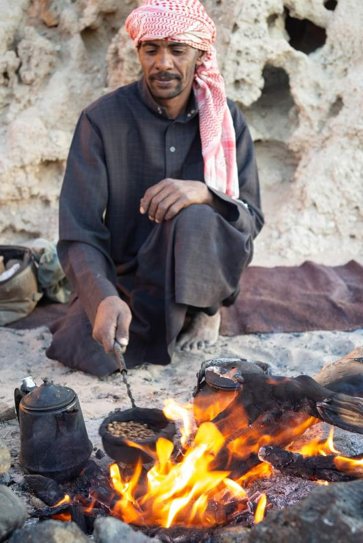
For example their welcome drink, the fabulous Jebena coffee.
Also the way of making bread. Making this bread does not require ovens, gas or electricity, nor does it needs pots. The dough is made of flour, water and salt and does not require fermentation. Wood is burned into embers while heating the sand below. As the embers are set aside, they dig a hole in the hot sand, similar to the chamber of an oven. Cover the dough with sand before placing the embers back on top. After half an hour, the bread will be removed from the hole and cleaned from sand and ember.
The name of the bread is Qaburi.
-On February 14, 2021, we received the sad news that Sheikh Ahmed Mansour Al-Abbadi passed away at the age of 98. He will always be remembered as a man of great poise and dignity, father of the tribe and gaurdian of the land.
Hamada, the eldest grandson has become the worthy successor as Sheikh after the death of his grandfather.


The 'Jebena' coffee:
-Apart from strong black sugar rich tea, the Ababda tribe to which our Bedouin team belong most common social drink is ‘Jebena’, or hand roasted coffee beans, that are ground with ginger and poured into a round earthen jar with a long neck.
With added water the jar is placed between the glowing embers of the fire to boil, and the coffee successively served with loads of sugar in small porcelain cups.
The minimum number of rounds to drink is three and you must end up with an odd number.
-If a guest doesn't drink its cup right away, it becomes the “cup of the sword.” This means the guest has come with a matter of urgencies, such as marriage or warfare, and he won't drink the coffee until the request is met. So be careful!!!


The 'Ma'aza tribe:
-After the Islamic conquest and tribes coming from Saudi Arabia, the Ababda tribe was the most important tribe in Egypt. Until about 250 years ago, Ma'aza tribes also began to emigrate from northwest Saoudi Arabia to the eastern desert. Fighting the resident Ababda forced the Ababda south to a smaller area in the eastern desert.
Since then, the Ma'aza Bedouin tribe, comprising about twenty subgroups of patrilineal clans, has made its homeland in roughly the northern half of Egypt's eastern desert, between the Nile Valley and the Red Sea. The total tribal area is about 102,000 square kilometers.
The Egyptian authorities do not formally recognize these Bedouin homelands and these areas are simply defined as sovereign Egyptian land.
To a tourist unfamiliar with a desert used by nomadic herders, large areas of the eastern desert may appear dry wasteland or pristine desert wilderness. More precisely, it is a cultural landscape shaped by the preferences and activities of the Bedouin over a period of many generations.
The Bedouin rely on oral tradition to perpetuate knowledge of all kinds, including knowledge of places.
Human life in this wilderness requires a rich knowledge of places. Functionally, places are among the resources that support Bedouin life in the desert (water sources are the best example) and serve as landmarks that lead to resources. Where landmarks are missing or misread, tragedy can ensue: many places are named after people who died of thirst.
Most graves are also located near water. Nothing to do with dying of thirst but with Islamic law and tribal custom that prescribes that the body of the deceased must be washed and buried on the day of death, but this is not always possible. Numerous places are named for those buried in less than ideal conditions.
Some Bedouins, like our driver Salama from the Khushmaan Ma'aza tribe, have a lot of desert experience and can give an impromptu lesson about typical Bedouins ecological associations.The Ma'aza pastoralist developed a conservation system with redundant mechanisms protecting the trees. One vital measure was simple naming the trees. The named tree is important on a number of levels: it serves as a living way-finding landmark. To cut down a named tree would be to remove a way-finding landmark that could mean life or death in a desert crossing.
Even the characteristic well-groomed shape of the acacia tree results from careful tending by herders and their monitoring of camel and goat browsing.
Some people think that Bedouin are rootless, placeless wanderers who overuse the resources of the commons. Bedouin are invested in knowing them, identifying themselves with them and using their resources carefully to perpetuate their way of life.
Most Khushmaan Ma'aza were pastoral nomads tending sheep, goats and camels and employing typical patterns of movement to take advantage of ephemeral pastures. Men worked intermittently in, and did the family shopping and trading with, communities of the Nile Valley and Red Sea coasts. Since then they have been settling down, and very few Ma'aza families now practice nomadic pastoralism. Their responses to the economic opportunities posed by tourism, have been the main factors behind this major socio-economic change. Young people would not have incentives to experience and learn about their desert anymore. Unless young people learn their environment, there will soon be no Bedouin life in their homeland.
If you would ask Salama 'How do places get their names?'. He will properly answered with this scenario: If you spent ten days of a month in a little wadi and people came and went and saw you there, they would call it Shi'b al-Khawaaja, the 'long Wadi of the Foreigner'.
The primary objects of Ma'aza place-naming are valleys and other drainages and flatlands, followed by jebels (mountains) and other kinds of rocky promontories and elevations, water sources, trees and shrubs, and routes and trails.
After drainages, the second most commonly named landscape features are rocky high places and rocks. The Ma'aza homeland is mainly stony rather than sandy. Rock, ridge, promontory, hill and mountain types range from boulders to mainland Egypt's highest mountain Jebel Shaayib al-Banaat (2,187m).

The Red Sea Mountains:
-One way to connect with nature is to learn about Earth's history...
Mountains form where two continental plates collide. Since both plates, the Africa and Arabia are of similar thickness and weight, neither will sink under the other. Instead, they crumple and fold until the rocks are pushed up to form a mountain range.
The Red Sea mountains are composed of volcanic sedimentary rocks of the Arabian-Nubian Shield. Although the rock itself is 550-900 million years old, the mountains were formed some 23-34 million years ago.
The Red Mountains are red because of the weathering of the iron sulphide minerals in the rocks. As the iron sulphide minerals weather, the iron "rusts" or oxidizes, turning the rock various shades of red.
Earthquake swarms are common in this area of the northern Red Sea, but most earthquakes are weak, ranging in magnitude from 0.3 to 3.5. The largest earthquakes, magnitude 6.1 and magnitude 5.1, occurred in 1955 and 1984 respectively.
-The Red Sea itself was formed by Arabia splitting from Africa as a result of continental drift. The sea continues to widen (2 cm/year) and it is believed that the sea will eventually become an ocean.


A Palaeolithic (Old Stone Age) site at Wadi Billeh:
-During its field campaign of 2003, the Belgian Middle Egypt Prehistoric Project of Leuven University and the Royal Belgian Institute of Natural Sciences set out to test a small cave in the Red Sea Mountains west of El Gouna near Hurghada and the wider area around this cave.
Wadi Billeh is a wadi draining the Red Sea Mountains. It finds it way to the Red Sea through a deeply incised gorge in the Abu Sha'ar Plateau west of El Gouna. The hill culminating at an elevation of 200 m, forms a cuesta of which the front is facing the Red Sea coastal plain. The hill consists of black basement rocks with a cover of brown-yellow Eocene sandy limestone.
Approximately 40 bone fragments were found which mainly belonged to large animals in the size range of large bovids (buffalo, aurochs, kudu). In addition, a few long bone fragments in the size range of medium-sized herbivores (dorcas gazelle, ibex or Barbary sheep) were present.
West of the hill a large flat pediment at an elevation of 140-100 m drains the area towards the gorge. Where the wadi enters its gorge a dune tends to block the entrance of the gorge. In its present state the dune has been breached by the wadi, but presume that, during the very dry periods of the Last Ice Age, the dune was able to block entirely the run off waters of the wadi. If this happened, a lake could be created in the upper parts of the Wadi Billeh basin. Severe erosion, aeolian as well as run off is probably responsible for this situation.
Gradually cleaning the desert pavement by the university team, 497 large artefacts occurred in the underlying loose sand. Lithic artefacts such as the flint, are clearly imported and mostly of excellent quality. Cortical flakes are also well represented.
(reference: Journal of African Archaeology)


